“Expect power outages throughout the region”
High Wind Warning starts at 3pm Tuesday January 9
From Western New York Weather, follow on Facebook
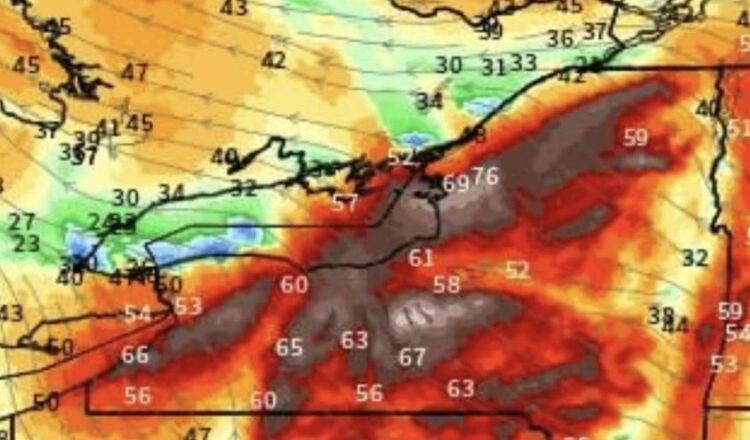
These are model forecasted winds just above the surface that will mix to the surface tomorrow.
This is not good for several reasons. Driving will be difficult, power outages are likely and trees are meant to sustain winds from a certain direction in this region, but winds expecially as strong as they will be coming from a different direction with not frozen grounds and a lot rain could cause trees to come down more so than normal.
•Damaging winds between 55 and 70mph expected
•Starts as snow likely a quick 1 or 2 inches before the changeover to rain
•Rainfall will be heavy at times likely between 1 inch and 2.5 inches with the highest amounts away from Lake Erie.
•Rain changes to a mix of rain and snow over to snow showers by Wednesday afternoon.
•Expect power outages across the region

From the US National Weather Service
…HIGH WIND WARNING IN EFFECT FROM 3 PM TUESDAY TO 4 AM EST WEDNESDAY… *
WHAT…South winds 25 to 35 mph with gusts up to 55 mph expected. *
WHERE…Steuben county. *
WHEN…From 3 PM Tuesday to 4 AM EST Wednesday. *
IMPACTS…Damaging winds will blow down trees and power lines. Widespread power outages are expected. Travel will be difficult, especially for high profile vehicles. *
ADDITIONAL DETAILS…The strongest wind gusts will occur in areas of elevated terrain, and along north and west facing slopes.
PRECAUTIONARY/PREPAREDNESS ACTIONS… People should avoid being outside in forested areas and around trees and branches. If possible, remain in the lower levels of your home during the windstorm, and avoid windows. Use caution if you must drive.


